Transportation modeling enables planners to better understand issues in their mobility systems, identify opportunities, and forecast the effects of development projects. In other words, transportation modeling is the basis for sound decisions for the future of mobility.
Given the importance of this topic, PTV Group has recently published The quick e-Guide to Transportation Modeling: Mastering sustainability, safety, and efficiency in mobility.
Here are some highlights from this free-to-download eGuide for mobility and transport planners – and for anyone interested in future transport:
Reliable solutions

Today, city and traffic planners must balance between various competing demands. The transition towards a more sustainable mobility ecosystem is more urgent than ever, to meet challenges like climate change and growing urbanization and to shape livable environments.
At the same time, the demand for mobility and easily accessible means of transport is growing steadily. Everyone expects safe, accessible, fast, and comfortable transportation. Planners are therefore tasked with coming up with reliable transport solutions that are affordable, efficient, and equitable.
In transport planning and the development of advanced mobility systems, forecasting travel behavior and demand for travel plays a crucial role. If you can estimate how and where people will be traveling in the coming years, you can make the right decisions for a future mobility system.
What is transportation modeling?
Transport models are the foundation of transportation and traffic planning. Transportation systems involve many components and stakeholders, each with their own perspective and interests. Further, transportation is closely linked to many other aspects of society.
Therefore, transportation planning is not usually about finding the ‘one optimal solution’. It is about considering a range of possible measures, policies and external conditions and then suggesting suitable actions for political or commercial decision making. Professionals call it “what if” analysis, or scenario analysis.
Transportation modeling tools enable the modeling experts to quickly develop different scenarios for a transport network. They can then test them under a range of assumed future demographic or economic conditions.
The question of where people will live and work in the future and how and where they will travel is crucial for planning infrastructure and transport services and for creating a future-proven mobility system. Travel demand models represent all transport-relevant decision processes that make people move.
Within a model, planners can build future scenarios for population growth, land use, transport networks and mobility behavior. They can then assess the impact of these changes.
This enables planners to determine whether a new highway lane is needed, how the public transportation network should be expanded to meet demand, where locations for new bus terminals or logistics hubs should be sited, or how people’s mobility behavior will change with autonomous vehicles.

Other free eGuides by PTV experts
For mobility and transportation professionals
Using transportation modeling

Transport models are the foundation of mobility and traffic planning. Using transportation modeling enables mobility experts to:
- Develop advanced and futureproofed transport strategies and solutions
- Conduct traffic analyses and forecasts
- Plan public transport services
- Determine ways to implement and foster infrastructure for active mobility, such as cycling
- Set framework to adapt to new mobility services, such as autonomous vehicles
Public Transport planning
To make public transportation the preferred choice of more people, planners need to address multiple questions: How to expand the public transport network? Where does a new bus line make sense, where to add new stops? Which frequency serves the demand?
A recent PTV survey, among hundreds of public transport professionals, reveals some of the answers to these questions.
Nevertheless, transportation modeling provides a detailed representation of all modes of public transport such as bus, taxi, as well as heavy and light rail. It allows planners to design reliable transit services which optimally serve passengers needs and allow efficient operations.

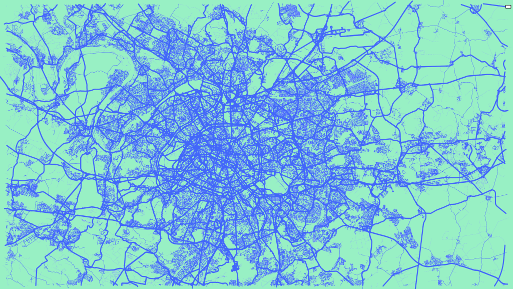
London’s new standard

Here’s an example on how London’s transportation authorities successfully use transportation modeling:
Transport for London (TfL) is responsible for the capital city’s transport system. Its Operational Network Evaluator (ONE) is a tactical highway traffic assignment model, used to assess the impact of schemes and to evaluate mitigation strategies.
Built in PTV Visum software, ONE provides a simplified representation of real-world road traffic conditions. It is one of the largest and most detailed junction-based highway models in the world: It covers 5,692 zones; 53,500 kilometers of links; and over 17,000 junctions modeled in detail, of which more than 5,500 are signalized.
The ONE model in PTV Visum has been intensively used by TfL for many years, with excellent results. It has helped to assess the impact of schemes including cycle routes and major road redesign schemes. It also helped the operational analysis of road and river crossing closures, and their impact on bus journey times.
Recently, TfL updated the model with the version PTV Visum 2022, which includes a move from scripted to built-in assignment. As a result, the model sets a new standard for the industry for highway assignment runtimes on regular hardware. It converges within 2.5 hours, including a bespoke outer loop for taxi in bus lane adjustments. Without this outer loop, which is unique to TfL’s application, the runtime would be even shorter less than 1 hour!
These faster run times will significantly increase the computation resources available for the TfL team and speed up the assessment of transport schemes in London.
Related Posts


