
Table of contents
When Liverpool City Council asked us to help tackle a persistent air quality issue on Hunter Street, we knew this was a challenge that couldn’t be solved with traditional infrastructure fixes.
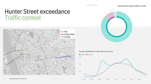
The corridor, carrying about 27,000 vehicles a day, was breaching legal NO₂ limits. Widening roads or rerouting traffic wasn’t viable: the street’s steep incline combined with a canyon effect from retaining walls trapped emissions, pushing concentrations above 45 µg/m³ – well beyond the 40 µg/m³ limit.
Our consultancy, Sweco UK, was brought in to support the city’s Clean Air Plan under the UK Government’s Joint Air Quality Unit. From the outset, we focused on targeted, local measures that would improve air quality without resorting to a citywide Clean Air Zone – a costly option with possible side effects for residents and businesses.
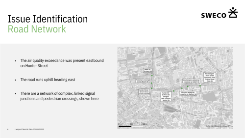
Site observations and traffic data revealed the issue wasn’t just vehicle volume but how traffic moved through the corridor. Repeated breakdowns in progression at closely spaced signals caused stop-start conditions and hard acceleration uphill – exactly the driving pattern that elevates emissions. That’s why we turned to PTV Vissim microsimulation for air quality improvement.
The Challenge
Traditional fixes like widening or reconfiguring geometry were impossible due to the site’s layout and topography. Reducing vehicle volumes was also unrealistic because the corridor serves as a key artery in the city’s network.
Instead, our focus turned to operational optimisation. The goal: smooth the flow to reduce stop-start driving and harsh accelerations that spike emissions – and demonstrate how traffic microsimulation tools can directly support emissions reduction and cleaner air.
Vissim Microsimulation for Air Quality Improvement
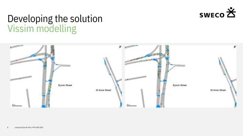
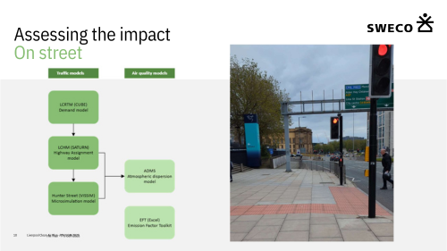
While Liverpool’s strategic SATURN model underpinned the broader Clean Air Plan, it wasn’t suited to testing signal-timing effects on vehicle trajectories. Drawing on a Transport for London study showing how retimed signals can improve air quality, we developed a detailed PTV Vissim microsimulation focused on the Hunter Street corridor.
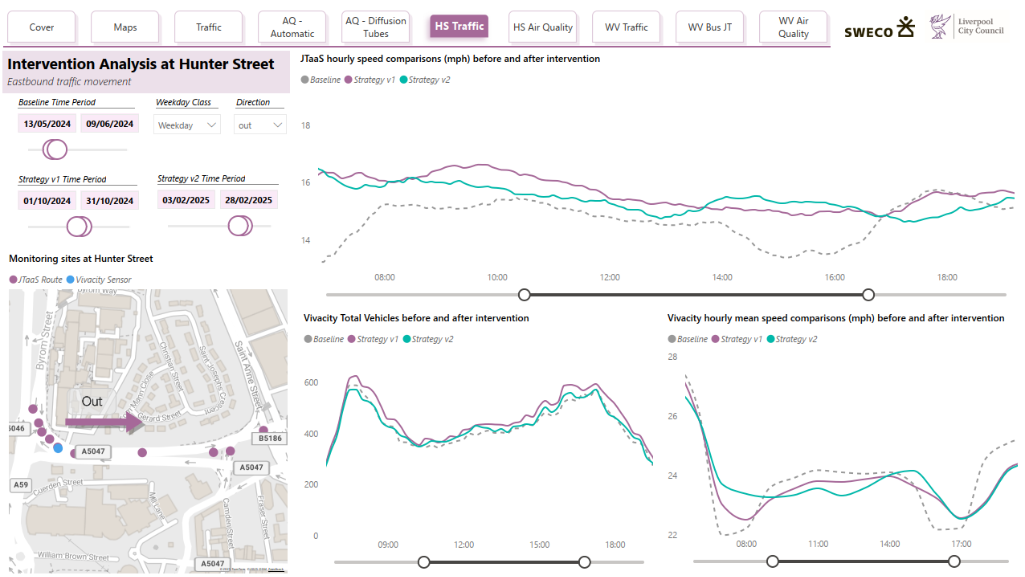
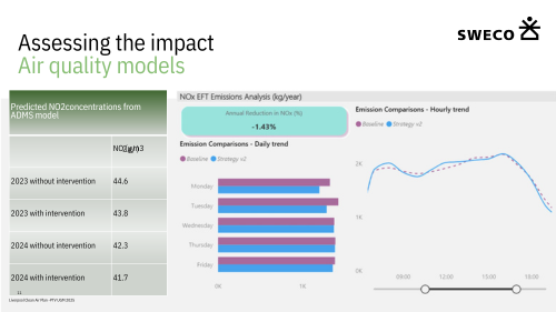
The Vissim model produced link-level speed and flow profiles, which were fed into the city’s ADMS atmospheric dispersion model to quantify the air-quality effects. Working closely with the city’s Urban Traffic Control (UTC) team, the model replicated existing conditions and tested alternative timings to improve traffic progression.
The preferred strategy demonstrated smoother flow, increased average speeds by about 5 mph, and reduced annual mean NO₂ concentrations by around 0.6 µg/m³ – a clear indication that optimising signal control through microsimulation can cut emissions without physical road changes.
Implementation and Early Results
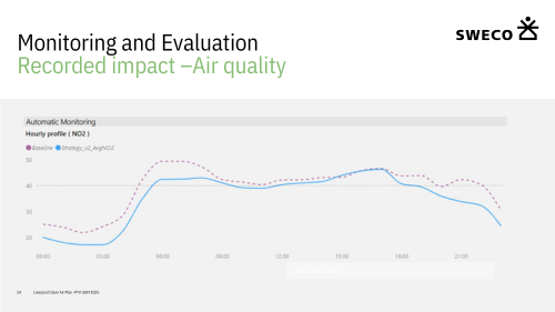
Based on these findings, we implemented the revised signal strategy during summer and autumn 2024, accompanying it with continuous monitoring.
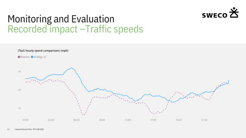
Early operational data show real-world average speeds have risen by about 1.6 mph – a smaller gain than the model predicted but fully consistent with expectations when moving from controlled simulation to field conditions. Robust evaluation requires 12 months of monitoring; those results are expected soon.
In the meantime, an Emissions Forecasting Toolkit assessment suggests the new strategy could reduce weekly NO₂ by roughly 1.43% – an encouraging sign that traffic optimisation through PTV Vissim microsimulation can translate directly into cleaner air.
Reliable Data and Verification
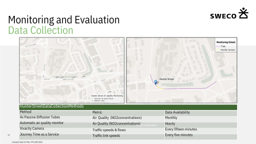
Monitoring draws on multiple independent sources to verify the impact: classified flows and speeds, link-level journey times, and air-quality readings from diffusion tubes and automatic stations. This triangulation provides a strong evidence base for decision-making and future refinement.
Why It Matters
Many cities face the same dilemma as Liverpool – localised pollution hotspots on strategic routes where heavy engineering or traffic restrictions aren’t feasible. The Hunter Street project shows how PTV Vissim microsimulation for air quality improvement can deliver measurable results through smarter signal control and minimal disruption.
Authorities increasingly favour this approach for three reasons:
- Targeted impact, minimal disruption. Signal retiming can be deployed within existing rights-of-way, avoiding costly civil works while addressing specific air-quality exceedances.
- Evidence-led and auditable. Combining microsimulation with dispersion modelling creates a transparent chain of evidence from intervention to outcome – exactly what regulators and the public expect.
- Scalable and adaptive. Strategies can evolve as monitoring reveals changes in demand, weather, or fleet mix, ensuring benefits are maintained over time.
Vissim microsimualtion: Lessons and Takeaways
- Model at the right scale. Strategic models are vital for network context, but vehicle-level trajectory changes live in microsimulation. Use each tool for what it does best and integrate outputs for robust results.
- Collaborate early. Close work with the UTC team ensured the tested signal strategies were not just theoretically optimal but fully implementable.
- Measure from multiple angles. Traffic, journey-time, and air-quality data each capture part of the picture; combining them yields the most reliable conclusions.
- Expect real-world variation. Field results often show smaller gains than modelled, but directionality matters – and optimisation is iterative.
The Bigger Picture
Across the transport sector, agencies are shifting towards non-infrastructure solutions – such as adaptive signal control, queue management, and speed harmonisation – to achieve air-quality and climate targets while budgets remain tight.
Microsimulation plays a central role by allowing teams to:
- Reveal the emissions impact of control logic by capturing stop-start cycles and acceleration profiles.
- Test multiple strategies before implementation, reducing risk and time-to-benefit.
- Build defensible business cases linking operational improvements to societal outcomes such as cleaner air and improved health.
Next Steps
With a full year of ratified air quality monitoring available in Q1 of 2026, Liverpool City Council and Sweco will soon confirm the annualised NO₂ effects and decide whether to retain, refine, or extend the strategy to nearby links and junctions.
Whatever the final figures, the project demonstrates a pragmatic pathway for local, data-driven solutions that align with national air-quality mandates – using PTV Vissim microsimulation for air quality improvement to deliver measurable, scalable progress toward cleaner urban mobility.

Optimize Your Transportation Network
Our free guide to
urban mobility planning: Challenges & solutions
Optimize Your Transportation Network
Our free guide to Urban Mobility Planning: Challenges & Solutions
Related Posts


