
Table of contents
What if we could test dozens of urban access points in a matter of weeks – without closing a single lane or pouring a drop of concrete? Urban access points (pasos y accesos urbanos) are the road segments that link regional corridors, such as highways, with city streets. They are critical for mobility and safety.
In Colombia, our team used PTV Vissim to simulate low-cost ‘soft solutions’ for these points. The result: insights that would have taken months of physical pilots, delivered in a fraction of the time and cost.
Urban access points: Challenge and opportunity
Urban access points are more than just transition zones; they are strategic nodes where regional and urban mobility intersect. These segments carry a high mix of users – private vehicles, freight, cyclists, and pedestrians – making them both essential and vulnerable.
In fact, national crash data revealed that nearly one in four road fatalities occurred on these access points, underscoring the urgent need for safer designs.
Traditionally, improving safety and efficiency in these areas relies on physical pilots -temporary interventions deployed on-site to test their impact. While effective, this approach is slow, costly, and limited in scale.
Testing even a handful of sites can take months and require significant resources, delaying decisions and leaving many high-risk locations unaddressed.
We saw an opportunity to change that. By using PTV Vissim, we could model dozens of scenarios virtually. We could explore how different interventions – such as speed – calming measures, curb extensions, or pedestrian waiting zones-affect both traffic performance and safety. In this project, we analyzed more than 20 urban access points in a controlled, data-rich environment, providing actionable insights without the logistical and financial burden of field pilots.

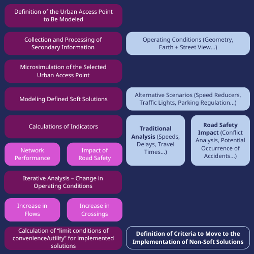
Our Approach: Modelling urban access points
We began by characterizing 319 access points nationwide using secondary data and geospatial tools. From this pool, we selected a representative sample for detailed modeling. In PTV Vissim, we built two scenarios for each connector:
- Baseline scenario: Current conditions without interventions.
- Alternative scenario: Incorporating soft solutions such as speed-calming measures and parking regulation.
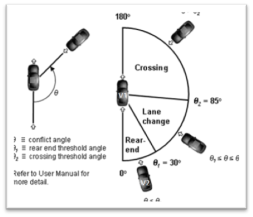
To evaluate these scenarios, we combined operational performance indicators – travel times, speeds, delays-with safety metrics derived from the Surrogate Safety Assessment Model (SSAM). This dual approach allowed us to assess trade-offs between efficiency and safety.
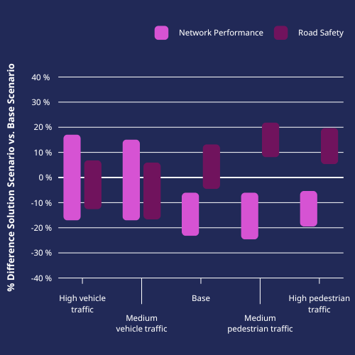
Key Findings
- Soft solutions work best in pedestrian-heavy contexts. When we simulated higher pedestrian activity, the benefits for safety were clear and did not significantly compromise network performance.
- High traffic volumes change the equation. In scenarios with heavy motorized traffic, some interventions reduced speeds but also increased delays, making them less suitable without complementary measures.
- Small changes can have big safety impacts. Even modest speed reductions translated into fewer simulated conflict points, especially at crossings.
Illustrative Scenario
Imagine a two-lane connector with frequent pedestrian crossings near a school zone. In the baseline scenario, vehicles traveled at 50 km/h, and SSAM detected multiple potential conflicts at crossing points.
After introducing soft solutions-curb extensions and a reduced speed limit – the average speed dropped to 35 km/h. While travel time increased slightly, the number of simulated conflicts decreased significantly.
This is the kind of trade-off we can quantify with PTV Vissim before making real-world changes.
Why Simulation Matters
This research reinforced the strategic value of simulation in planning. By using Vissim, we were able to:
- Scale up analysis: Evaluate more than 20 sites in weeks, compared to the months required for physical pilots.
- Test multiple variables safely: Explore different traffic conditions, pedestrian flows, and design options without disrupting real-world operations.
- Prioritize investments: Identify which access points and interventions offered the greatest safety gains with minimal operational trade-offs.
Simulation does not replace field pilots, but it optimizes them. It helps us focus resources on the most promising solutions, reducing uncertainty and accelerating decision-making.
Conclusions
Through this research, we confirmed that simulation is not just a technical tool – it is a strategic enabler for safer, smarter mobility planning.
By using PTV Vissim, we were able to anticipate the impacts of soft solutions on both safety and network performance before making any physical changes.
This allowed us to identify where these interventions deliver the greatest value – particularly in pedestrian-heavy contexts – while avoiding scenarios where they could compromise efficiency.
Our experience shows that integrating microscopic simulation into planning workflows accelerates decision-making, optimizes resource allocation, and reduces uncertainty. It does not replace field pilots, but it makes them more targeted and effective.
For us, this approach represents a shift toward evidence-based, data-driven planning that benefits both mobility professionals and the communities they serve.

Test your ideas before you build
Discover how PTV Vissim can help you evaluate interventions virtually, saving time and resources while improving safety outcomes.
Ready to test your ideas before you build?
Discover how PTV Vissim can help you evaluate interventions virtually,
saving time and resources while improving safety outcomes.


