Table of contents
How does a BRT optimization look like? Yaoundé, the capital of Cameroon, is struggling to provide its millions of residents with efficient public transport. However, an innovative project undertaken by students in Germany shows how digital modelling tools can overcome these challenges and transform mobility in the city.
Our team used PTV Visum and PTV Model2Go (M2G) modelling software to design additional taxi feeder routes that integrate with the city’s planned Bus Rapid Transit (BRT) network. We expect this pioneering approach to increase accessibility and optimize usage of resources. If implemented, it will help to make Yaoundé’s urban transport system more sustainable and efficient.
The Project
As part of the joint Master’s program in Sustainable Mobility at the University of Applied Sciences Rhein-Main and the Frankfurt University of Applied Sciences, students collaborate internationally and apply their skills to real-world scenarios. In this context, our team contributed to the German Corporation for International Cooperation’s (GIZ) engagement in Yaoundé.
We were tasked with designing suitable paratransit routes for the city’s future BRT network. The project aimed to complement the city’s Sustainable Urban Development Plan (SUMP) and improve accessibility.
Yaoundé, which has a population of over 3.5 million and an area of 180 km², relies primarily on passenger car taxis. The GIZ “MoVe Yaoundé” project (jointly implemented with the French Development Agency on behalf of BMZ with EU co-funding), included plans for a BRT network published in the SUMP in 2019; however, the city’s topography and dense urban development posed significant challenges to achieving full coverage with standard buses.
To address these challenges, our student team used PTV M2G and PTV Visum to analyze the potential of supplementary taxi-operated feeder routes.
PTV Model2Go software delivers ready-to-use digital transport models by processing data sources like OpenStreetMap. This tool saved us time and gave us a solid base for our planning work.
PTV Visum transportation planning tool supports the modeling of entire transport networks and simulation of traffic, public transit, and demand scenarios. It’s widely used by planners and decision-makers to optimize transport infrastructure and services, making it a perfect fit for our project.
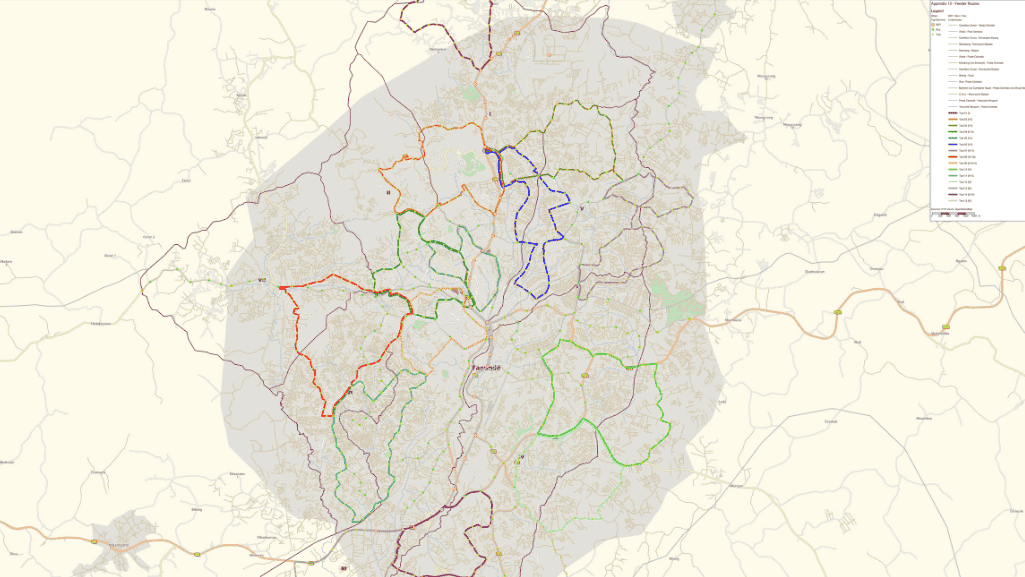
The resulting design connected previously underserved areas to the BRT network, significantly improving accessibility, reducing congestion, and cutting travel times.
Methodology
Initially, the BRT network existed only as a conceptual plan, and there were no digital models of Yaoundé’s transport infrastructure. The M2G model provided the foundational data necessary for developing a comprehensive transportation system. First, our team translated the SUMP’s bus network into PTV Visum. Then, they added and edited stops, established bus lines, and identified densely populated areas lacking access to public transportation.
Initially intended to cover only one of Yaoundé’s seven districts, the project’s scope expanded as the M2G model revealed sufficient infrastructure data for efficient route planning across the entire city. This enabled our team to design comprehensive feeder routes, greatly enhancing the bus network’s reach.
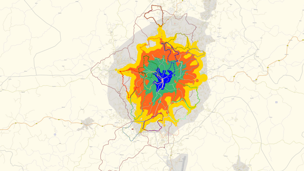
The M2G model’s detailed zoning data, including land use, population, and points of interest, enabled us to assess accessibility. We generated isochrones, or travel-time maps, around each stop and intersected them with population data to determine the percentage of the population living within a five-minute walk.
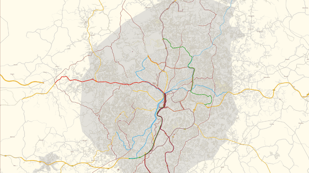
Further analysis involved using Visum-generated timetables to calculate travel times along the transport network with the city center as the origin point. This analysis revealed that most of the city could be reached within 40 minutes – a reasonable travel time under local conditions. However, the airport remained outside this range, prompting us to add a dedicated BRT line connecting the city center and airport.
BRT optimization: Obstacles
The absence of initial digital data models presented us with a significant challenge. Our team overcame this hurdle using M2G, which provided the necessary infrastructure information. As the project progressed, additional population distribution data became available, validating the initial assumptions and strengthening the model’s reliability.
Results & Outlook
Within just three months, the combination of PTV M2G and PTV Visum enabled us to create a detailed digital public transport model based entirely on publicly available sources like OpenStreetMap. The resulting feeder routes significantly extended Yaoundé’s bus and BRT network coverage.
Future expansions could involve incorporating passenger demand data from field surveys, optimizing routes for ecological or financial benefits, such as reducing carbon emissions, and determining appropriate vehicle capacities for different routes. These enhancements would refine the existing system and contribute to a more sustainable and accessible transportation network in Yaoundé.
Key Performance Indicators
- Accessibility Improvement: The project increased the potential population living within a 5-minute walk from a bus stop from 30% to 50%, a 65% improvement.
- Enhanced Travel Speed: The new feeder routes significantly reduced travel times to access the BRT network and facilitated connections to remote areas, including the airport.
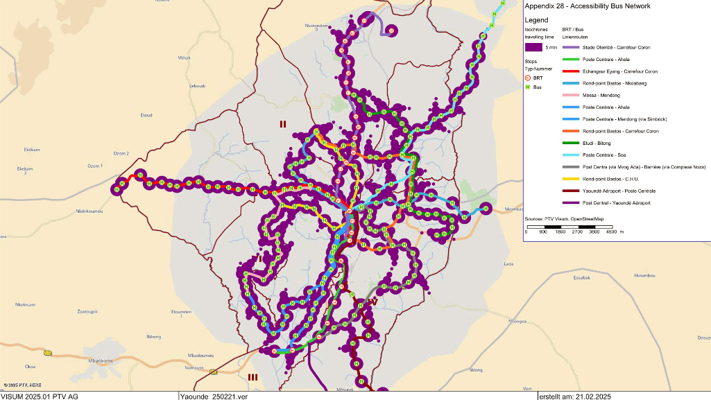
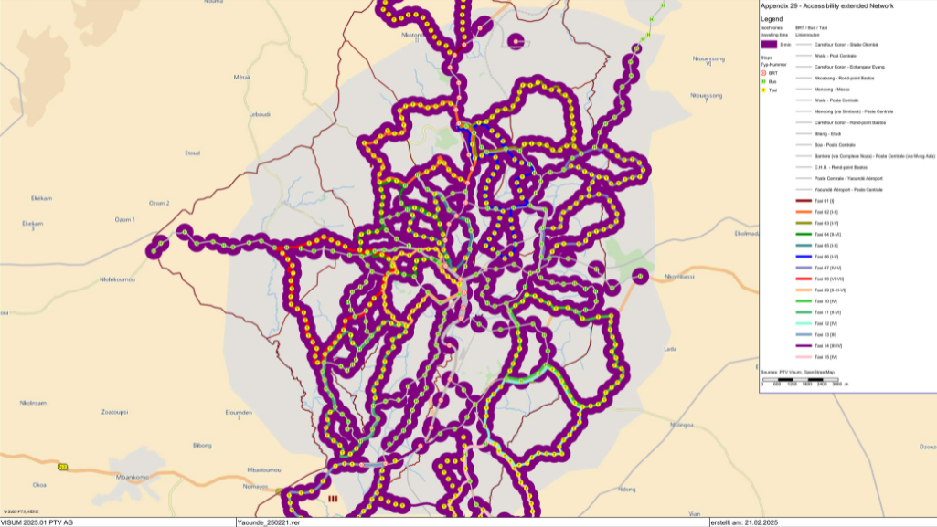
Improved accessibility: A comparison of the area within 5 minutes reach of a bus stop in the original BRT network (left) and after adding the paratransit routes (right).
BRT optimization: Conclusion
This project illustrates how innovative use of transport planning software like PTV Visum, combined with detailed modelling via M2G, can address complex urban mobility challenges. By designing an integrated system of BRT and feeder routes, our team contributed to Yaoundé’s sustainable urban future, setting a benchmark for similar initiatives in rapidly growing cities worldwide.

Spotlight Talk
on the topic
Take a look on modeling taxi feeder routes – directly explained by our experts
Spotlight Talk on the topic
Take a look on modeling taxi feeder routes – directly explained by our experts
Related Posts


