
Table of contents
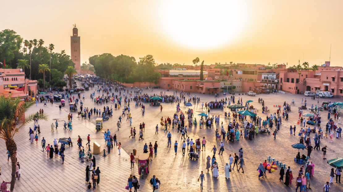
A vibrant city where ancient souks meet modern streets, Marrakesh is famous for its lively atmosphere. But behind the charm lies a growing challenge: traffic congestion. As the city’s population swells to one million and tourism flourishes, navigating Marrakesh’s streets has become increasingly complex.
To address these mobility challenges, transportation company SDL-Marrakesh Mobility, in collaboration with local authorities, launched a comprehensive Public Transport Master Plan. As part of this initiative, I was involved as a Subject Matter Expert specializing in transport planning and traffic modeling.
Using PTV Vissim, I conducted in-depth data analysis, advanced modeling, and strategic planning to redesign traffic patterns and enhance transport efficiency. By simulating and testing various scenarios with Vissim’s powerful multimodal traffic simulation capabilities, we successfully transformed Marrakesh’s busiest roads into smoother, more efficient corridors.
This case study highlights how PTV Vissim played a pivotal role in reducing traffic congestion, improving public transport efficiency, and enhancing pedestrian safety — contributing to a more sustainable and accessible city.
Methodology: How we used PTV Vissim
With PTV Vissim, we followed a step-by-step methodology that combined technical precision with practical insights.
Step 1: Data collection – the foundation
Creating an accurate simulation begins with reliable data. We conducted extensive field research and gathered detailed insights from a variety of sources:
Traffic counts:
We monitored vehicle volumes at key intersections to capture peak hour patterns.
Modal split analysis:
Data on vehicle types (buses, taxis, private cars, etc.) helped us understand mobility behavior.
Public transportation data:
We integrated timetables, stop locations, and passenger flow patterns to improve bus efficiency.
Pedestrian movements:
Marrakesh’s vibrant streets are rich in pedestrian activity, which requires special analysis to ensure safety.
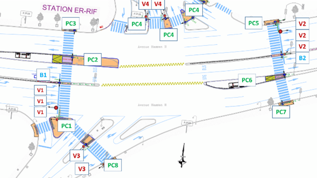
This comprehensive data set provided the basis for an authentic digital twin of the city’s transportation network.
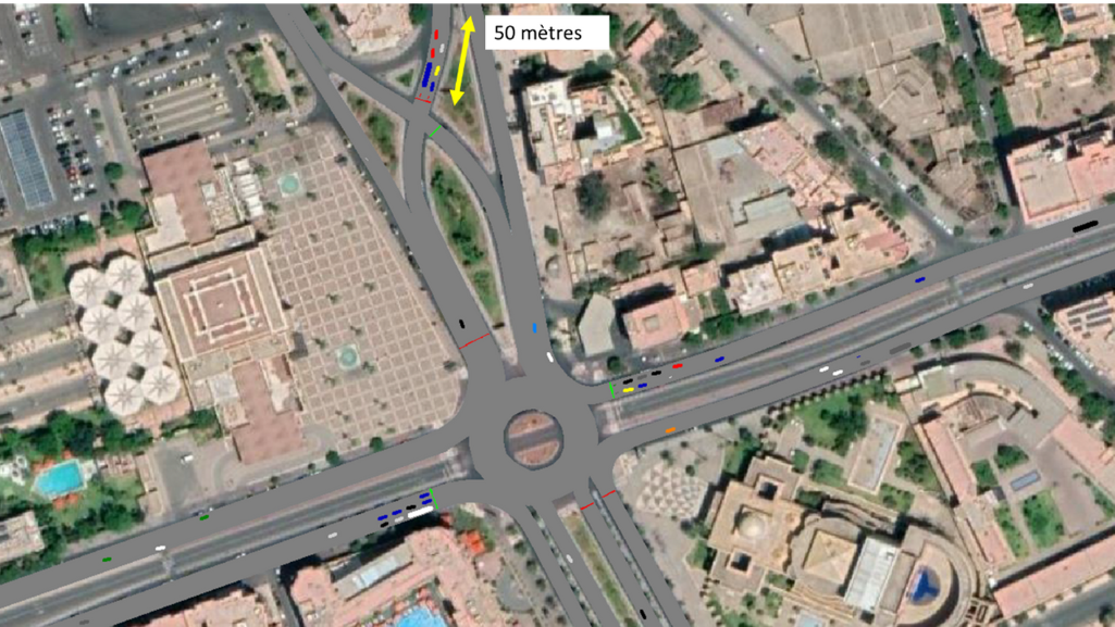
Step 2: Model development – bringing Marrakesh to life
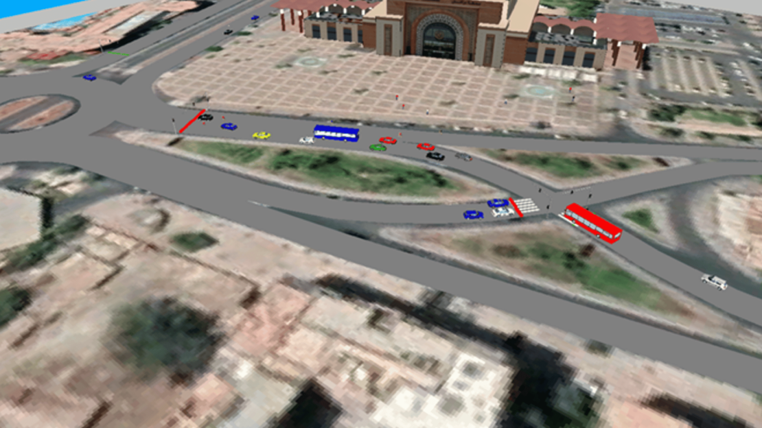
We used PTV Vissim to recreate the city’s complex road network. Key elements included
Intersection geometry:
Detailed replication of road layouts, including roundabouts, complex intersections, and narrow streets common in Marrakesh.
Traffic signal configurations:
Each signal phase was modeled to reflect real-world timing patterns.
Driver behavior calibration:
We adjusted Vissim’s behavioral models to mimic local driving habits, ensuring realistic vehicle interactions.
Public transport integration:
Bus routes, stops, and priority measures were embedded to evaluate service performance.
By fine-tuning these elements, the simulation accurately mirrored the dynamic traffic conditions of Marrakesh.
Step 3: Scenario testing – finding the best solutions
We tested multiple interventions in PTV Vissim to evaluate impacts on travel times, delays, and queues.
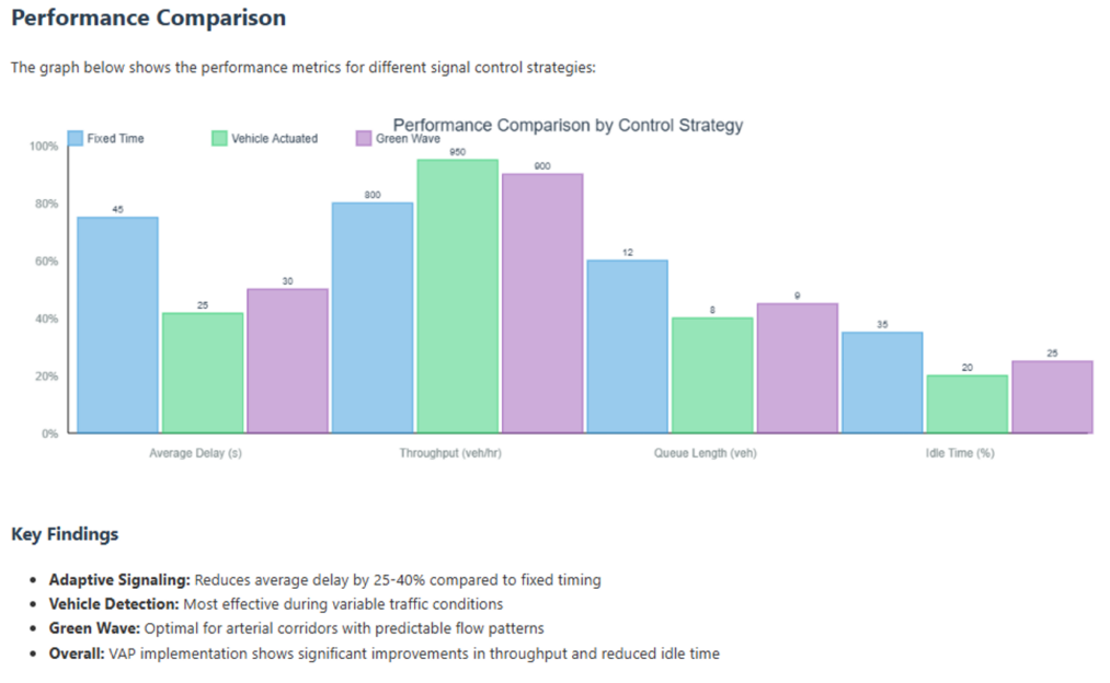
Adaptive Traffic Signal Control: Using VAP (Vehicle Actuated Programming), we simulated real-time signal adaptation based on vehicle detection; Green wave coordination along corridors; and optimized phase sequences to cut idle times. These adjustments reduced delays by up to 20% in high-traffic areas.
Dedicated Bus Lanes: With the Public Transport (PT) module, we evaluated PT Lines and Stops Configuration, modeling stop locations, dwell times, and priorities; Priority Rules & Conflict Areas to minimize bus delays at intersections; and queue Spillback Management to assess impacts on adjacent traffic. Results showed a 15% improvement in bus travel times with minimal disruption to other traffic.
Pedestrian Flow Optimization: Using the Pedestrian Module, we tested improvements to crossing safety and flow – Dynamic Crosswalk Control with demand-based signal phases; Conflict Area Analysis to pinpoint and redesign high-risk zones; and crowd Dynamics Simulation to assess varying pedestrian volumes. These changes cut pedestrian-vehicle conflicts by 30%.
Step 4: Validation – ensuring real-world accuracy
We calibrated and validated the model to ensure alignment with observed data from Marrakesh.
Data Collection and Benchmarking
Validation was based on: Traffic counts and queue lengths at key intersections; GPS-based travel time surveys to capture real travel times across major corridors; and vehicle composition data. This data served as the benchmark to validate the accuracy of our Vissim model.
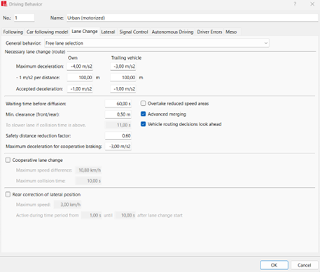
Calibration Process – Fine-Tuning Vissim Parameters
Key adjustments included: Car-Following Model (Wiedemann 74 & 99) parameters (e.g., CC0, CC1, CC2) to simulate short headways and aggressive driving; Lane-Changing Model factors like reduced safety distances and cooperative behavior; Priority Rule Adjustments to reflect informal merges and pedestrian crossings; and conflict Area Calibration for bottleneck simulation, using Vissim’s conflict markers.
Validation Process – Ensuring Model Accuracy
We compared outputs using these Vissim features: Link Evaluation tool for vehicle delay; **Queue Counter **for queue length accuracy; and Travel Time Analysis Tool to align simulations with GPS data. Final models showed less than 5% deviation from real-world observations.
Outcome – A Reliable Decision-Making Tool
The validated Vissim model enabled reliable testing of adaptive signals, bus lanes, and pedestrian improvements. It supports evidence-based mobility planning tailored to Marrakesh’s conditions.
Challenges & solutions
We encountered several challenges. With PTV Vissim’s simulation capabilities and a data-driven approach, we transformed these obstacles into opportunities for mobility improvements in Marrakesh. Here are some of the challenges and the solutions:
Data Gaps and Inconsistencies
There was a lack of reliable, up-to-date traffic data, especially for public transport ridership and pedestrian movement.
Our approach:
- Conducted extensive field observations and manual counts at key intersections during peak hours.
- Collaborated with local authorities and transit operators to validate and enhance data accuracy.
- Used Vissim’s calibration tools to ensure simulations reflected real-world traffic behavior.
Complex Road Network and Driver Behavior
Marrakesh’s streets, characterized by informal driving patterns and mixed traffic environments, posed unique modeling challenges.
Our approach:
- Calibrated driver behavior in Vissim to replicate local habits like aggressive lane-changing and informal merging.
- Modeled high-interaction areas where taxis, motorcycles, and pedestrians share space.
- Conducted iterative tests to fine-tune model accuracy under varied conditions.
Balancing Public and Private Traffic
Introducing dedicated bus lanes and signal priority improved public transport but risked increased delays for private vehicles.
Our approach:
- Used scenario testing to optimize bus lane locations and signal timings.
- Integrated adaptive signal controls to balance improved bus flow with minimal disruption to general traffic.
Stakeholder Alignment
Aligning priorities among city officials, transport operators, and community leaders was essential for successful implementation.
Our approach:
- Hosted interactive workshops using Vissim simulations to clearly communicate the projected outcomes.
- Leveraged visualizations to build stakeholder trust and secure consensus on proposed solutions.
Results & KPIs
The combination of PTV Vissim’s data-driven insights and strategic modelling led to significant improvements in traffic flow, public transport efficiency, and pedestrian safety:
20% Reduction in Intersection Congestion: Through the optimization of traffic signal timings and the implementation of adaptive traffic control systems, we achieved a 20% decrease in vehicle delays at critical intersections. This directly enhanced traffic flow, especially in high-traffic and bottleneck-prone areas such as marketplaces, school zones, and tourist hubs.
15% Improvement in Bus Travel Times: Dedicated bus lanes and signal priority measures were introduced to streamline public transport operations. These efforts led to a 15% reduction in average bus travel times, significantly improving service reliability and encouraging a modal shift towards public transport.
30% Reduction in Pedestrian-Vehicle Conflicts: Comprehensive pedestrian safety measures – including redesigned crosswalks, refined signal timings, and improved signage and visibility – resulted in a 30% reduction in pedestrian-related safety incidents. These improvements enhanced walkability and made key pedestrian areas across the city safer and more accessible.
Optimized Traffic Flow in Key Corridors: Scenario-based analysis in Vissim allowed us to identify and implement high-impact solutions for Marrakesh’s busiest transport corridors. This ensured smoother transitions between major intersections and effectively reduced chronic congestion points.
Outlook & conclusion
The insights gained through Vissim simulations are now informing a range of ongoing and upcoming initiatives, including:
Expansion of Dedicated Bus Corridors:
Enhancing the reliability and coverage of the city’s public transit network.
Integration of Intelligent Traffic Management Systems:
Deploying real-time, adaptive signal control technologies to continuously optimize traffic flow based on live conditions.
Development of Safer Pedestrian Zones:
Prioritizing walkability and safety in tourist-heavy and densely populated areas through thoughtful urban design and traffic-calming measures.
In addition to the immediate operational benefits, the project has provided local authorities with a robust, simulation-based decision support tool. This allows planners and policymakers in Marrakesh to assess the impact of proposed infrastructure changes before they are implemented.
Marrakesh’s successful experience demonstrates how data-driven simulation can lead to improvements in urban mobility. We have shown that complex mobility challenges can be addressed with solutions such as PTV Vissim, providing a roadmap for other cities facing similar issues.

A data-driven transport model for your city
Use PTV Vissim simulations
to optimize traffic,
public transport and safety
A data-driven transport model for your city
Use PTV Vissim simulations to optimize traffic, public transport, and safety
Related Posts


