Transport planning plays a crucial role in designing and managing transportation systems to facilitate the smooth movement of people and goods. It involves a strategic analysis of current needs, future demands, and the implementation of measures to ensure accessibility, sustainability, safety, and economic development.
Transport modeling serves as a valuable tool in supporting transport planning endeavors. By utilizing digital twins, it allows for the testing of various scenarios to predict how changes in infrastructure, policies, or demand will impact transportation systems and vice versa. This predictive analysis aids planners in making informed decisions by providing insights into potential outcomes such as traffic flow, congestion levels, environmental impacts, and cost-effectiveness before implementation.
The approaches to transport modeling can be broadly categorized into the following:
Highway Network Models: These models determine the flow of traffic on road networks by assigning vehicles to routes based on factors such as travel time, distance, and congestion levels, thereby estimating journey times and other costs associated with road travel.
Public Transport Network Models: These models allocate passengers to services and routes, estimating journey times and costs associated with public transportation.
Demand Models: These models assess the number of people desiring travel from one point to another and the preferred mode of transportation based on the quality of the transport system as indicated by the Highway and Public Transport Network Models.
GIS and Data Analysis: Given the substantial amount of data involved in transport models, including geospatial information, a robust GIS and data analysis capability is crucial.

Different approaches to transport modeling
The choice of modeling approach depends on the insights and information required. For example, an organization like Network Rail in the UK primarily focuses on analyzing past, present, and future usage scenarios for the rail network, which is why Public Transport Network Modeling in PTV Visum is generally sufficient for their needs.
However, there are interdependencies between modeling approaches. For instance, the demand for rail travel between two cities depends on the quality of both rail and road networks, leading to a demand-supply loop. Therefore, a comprehensive strategic transport model typically integrates Highway, Public Transport, Demand Modelling, GIS, and Data Analysis in a single platform.
Traditionally, integrating different software packages for various modeling types has led to complex systems that are time-consuming, difficult to use, and interpret. PTV Visum addresses this challenge by providing market-leading methodologies for all types of modeling, along with a built-in GIS and efficient data analytics capability. This integrated approach allows for a full multi-modal variable demand model within a single software solution.
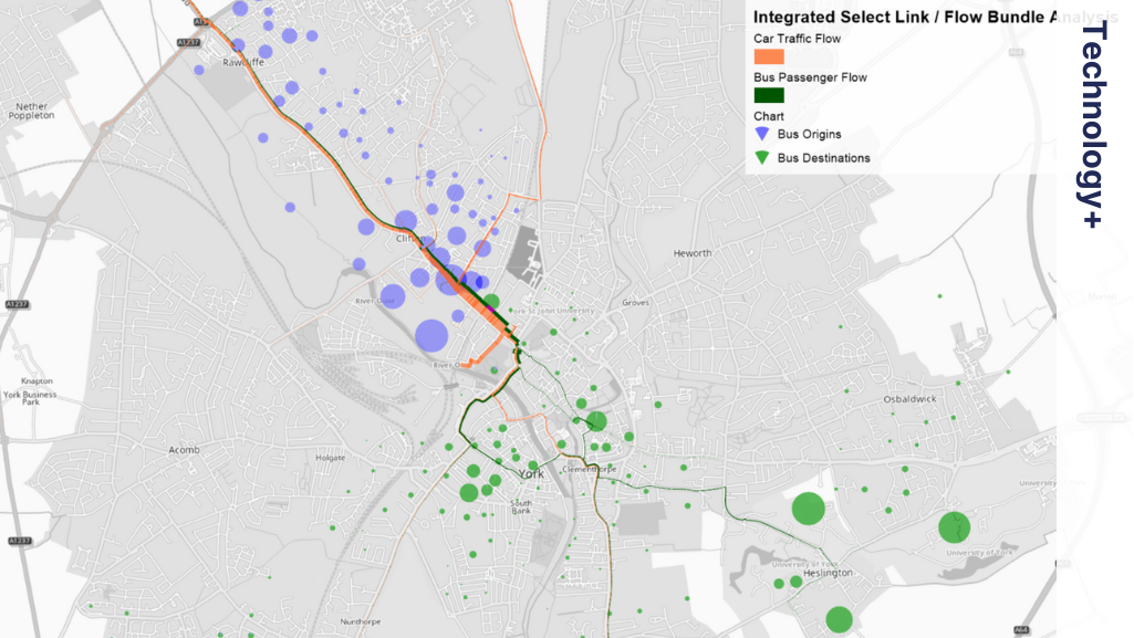
A recent example of the efficiency of PTV Visum is the City of York strategic transport model, which includes junction-based highway modeling, timetable-based public transport modelling, nested-demand modelling consistent with UK Transport Analysis Guidance (TAG), and built-in GIS and data analysis. With approximately 700 zones, this model runs efficiently, with highway assignment taking 3 minutes, public transport modeling 10 minutes, and the demand model 5 minutes, completing a full demand-supply loop in under 20 minutes.
Furthermore, PTV Visum simplifies analysis by allowing all outputs to be analyzed in an integrated manner within the same package. For example, understanding the impact of road congestion on bus passengers becomes seamless. Additionally, the financial benefit of licensing only one software and training staff on a single platform makes PTV Visum a cost-effective solution.
PTV Visum also facilitates integration between different software tools. For instance, the integration between PTV Visum and PTV Vissim allows for seamless transfer of information for microsimulation modeling, making the process significantly easier for transport engineers. The software is engineered to support open data and standards, such as native Python integration, Open Matrix OMX format, ingestion of OpenStreetMap networks, and more.
In conclusion, PTV Visum offers a comprehensive solution for transport modeling, eliminating the need for experts to build connections between siloed software. By simplifying the modelling process and enhancing user experience, PTV Visum maximizes efficiency and effectiveness in transport planning, enabling consultants and local authorities to make more informed decisions with their valuable time and resources.


