Comprising 10 neighborhoods, 40,000 residential units and 360,000 square meters of gross floor area (GFA) for commercial development, the East Coast Extension is expected to become an increasingly busy area of Singapore. This presents several challenges for urban planners, who must plan for an environment that is suitable for residents, pedestrians, and vehicles, without compromising ease of mobility.
A major challenge is the potential problems that arise from having a car-centered urban plan. By extension, commercial and residential development in the area will lead to an exponential increase in the number of residents and visitors.
These issues will be magnified in the future by newly announced plans for a ‘Long Island’ in the area, which will see 800 hectares of land reclaimed for new coastal and reservoir parks and waterfront living.
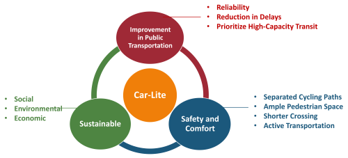
To address these issues, we completed a project that proposes a mobility corridor aligned with a car-lite vision. We focused on creating an efficient road network that encourages public and active transportation, thereby reducing reliance on private cars.
This 2023 modelling project is part of a Masters Capstone Project for the National University of Singapore. It was headed by Chloe Tie, of Singapore-based consultancy Surbana Jurong, and teammates Wan Weiqi, Feng Siqi, Mei Zihan, Wang Haowei and Zhou Zijin.
Guided by Professors Xie Litian and Liu Yang, Chloe and her team utilized PTV Vissim software to propose the future of mobility in the East Coast Extension development in Singapore.
A progressive mobility corridor
Our team was inspired by the success of Barcelona, which has grouped several city blocks (superblocks) together and restricted vehicular access. By closing internal streets to vehicles and restricting turns, these superblocks prioritize residents and pedestrians, fostering a sense of community and well-being.
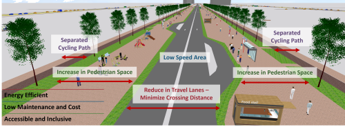
Similarly, the team’s design for the East Coast Extension included progressive scenarios that emphasized restricted turning movements and increased pedestrian space. The use of PTV Vissim was instrumental in modeling traffic projections to ensure the viability of the proposed mobility corridor.

Enhancing public transport
Navigating the challenges of transitioning from a car-centric to a car-lite development, this project addressed issues such as potential traffic congestion and the need for enhanced public transportation.
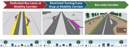
PTV Vissim facilitated scenario testing, allowing the team to assess the impact of dedicated bus lanes, turning restrictions and lane reductions.
The proposed solutions aimed to improve road safety, accessibility, and sustainability, setting the stage for a transformative urban environment

The results
Using the PTV Vissim models, our team achieved these results:
Traffic flow and congestion reduction: PTV Vissim’s traffic simulation capabilities showed a significant improvement in traffic flow, especially along the mobility corridor. The reduction of lanes resulted in a more streamlined and efficient movement of vehicles, with a noticeable reduction in congestion levels. Dedicated bus lanes and turning restrictions played a key role in reshaping traffic dynamics, in line with the overall goal of achieving a car-lite environment.
Public Transportation Reliability and Accessibility: The gradual transition from dedicated bus lanes to a long-term vision of a bus-only corridor showed a significant improvement in the level of service (LOS) for public buses. The corridor design focused on high-capacity transit, resulting in increased efficiency, reduced delays, and a reliable public transportation system.
Pedestrian and Bicycle Safety: The reduction in travel lanes resulted in improved safety for pedestrians and bicyclists. With narrower roadways, shorter crossing distances, and designated bike lanes, the mobility corridor became a safer and more accessible space for active transportation.

Watch the modeling
Bus-only corridor
Restricted turning lane
Dedicated bus lanes
Conclusion
The proposed mobility corridor for the East Coast Extension demonstrates the concrete results of data-driven planning and optimization through the application of PTV Vissim.
This project serves as a demonstration of the practical implications of public transportation optimization for the community and commuters.


