
Table of contents
Introduction
Can advanced modelling software help improve public transport in areas that go through deep economic and demographic changes? At SUM LAB, a transportation research group of the University of Cantabria, we recently embarked on a mission to find this out. By using PTV Lines and PTV Visum software tools, we proved that it can be done. Here is our story.
Cantabria and its public transport challenges
Cantabria, a region on the Atlantic coast of northern Spain, is home to nearly 600,000 people. The main form of public transportation is buses, operated by various private companies and managed by the regional government. A commuter rail system serves urban areas.
The current concession map (the contract between the Cantabria government and the bus operators) reflects nearly 60 years of evolution, shaped by regulatory changes, adjustments, and consolidations.
However, recent socio-territorial transformations have significantly altered settlement patterns. Urban areas have experienced economic growth, while rural regions face depopulation and aging demographics, leading to significant mobility challenges. The existing transport contracts are no longer effective in addressing these evolving needs.
At the University of Cantabria, we took it upon ourselves to improve the situation. This project aimed to develop a new concession map for regular inter-city bus, replacing the outdated system to better serve the mobility requirements of citizens.
Our primary goal was to enhance connectivity while ensuring optimal public expenditure efficiency. The central question driving initiative was: How can Cantabria’s public transport network be restructured to provide improved service levels while maintaining cost-effectiveness?
Methodology
The methodology we adopted for the project followed a sequential structure, starting with comprehensive data collection across all geographic areas and stakeholder groups.
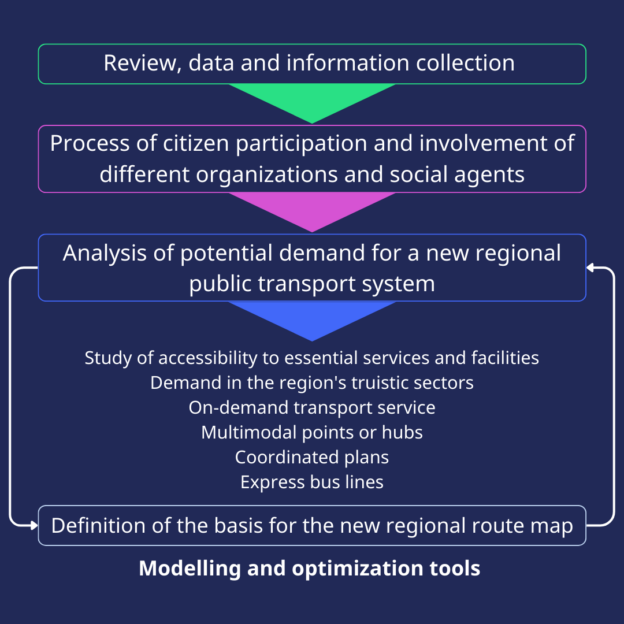
The subsequent diagnostic phase involved an in-depth analysis of the current mobility landscape, focusing on potential demand for a new regional transport system.
Finally, the project culminated in the definition of the new regional route map using advanced modeling and optimization tools such as PTV Visum and PTV Lines.
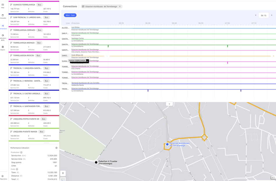
We chose PTV Visum for its ability to model the current system using demand data, accurately reproduce its operation and provide key service level indicators such as accessibility and journey times, such as isochrones from strategic points in the region. PTV Lines was then selected for its intuitive and easy-to-use interface, which allowed for fine-tuning minor modifications to route details, stop locations and timetables.
While the routes and timetables were initially defined in PTV Visum, PTV Lines facilitated more detailed refinements, ensuring better timetable coordination at key points such as stops where several lines or stations converge, thus promoting intramodality and improving collaboration with stakeholders.
In addition to regional buses and commuter trains, the Visum model also includes private transport. This allows for a more holistic analysis of the most important origin-destination mobility pairs, and thus an attempt to improve the provision of public transport in pairs dominated by private transport.
The three-step methodology included:
1. Current System Analysis
- A thorough review of the existing transport system based on demand data.
- Identification of high-demand areas and travel matrices to inform redesign efforts.
2. System Modeling with PTV Visum
- Simulation of the existing network to evaluate service level indicators such as accessibility and travel times.
- Scenario testing, including fixed-route networks, zonal subdivisions, and hybrid models.
3. Final Design with PTV Lines
- Detailed route adjustments, stop placements, and timetable refinements.
- Optimization of operational costs and coordination of intermodal connections.
After designing the new scenario in PTV Lines, it was re-imported into PTV Visum for validation, ensuring that the proposed design met service and operational objectives.
Results of the modeling
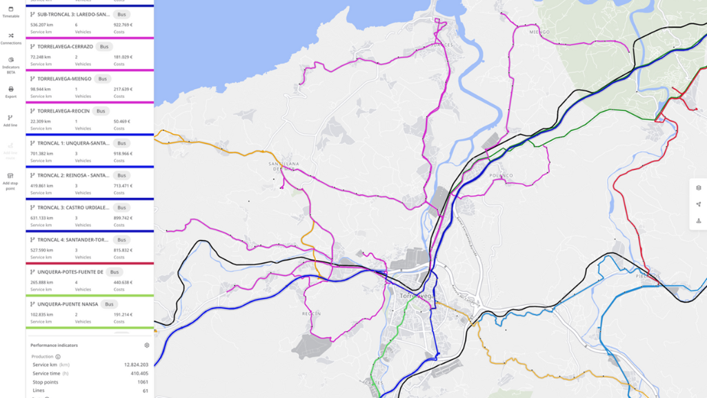
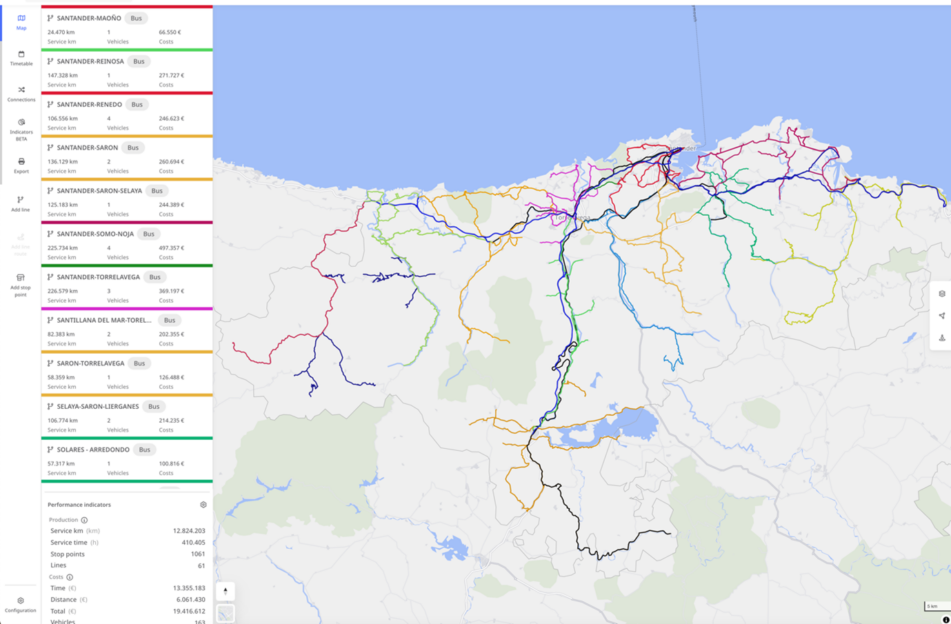
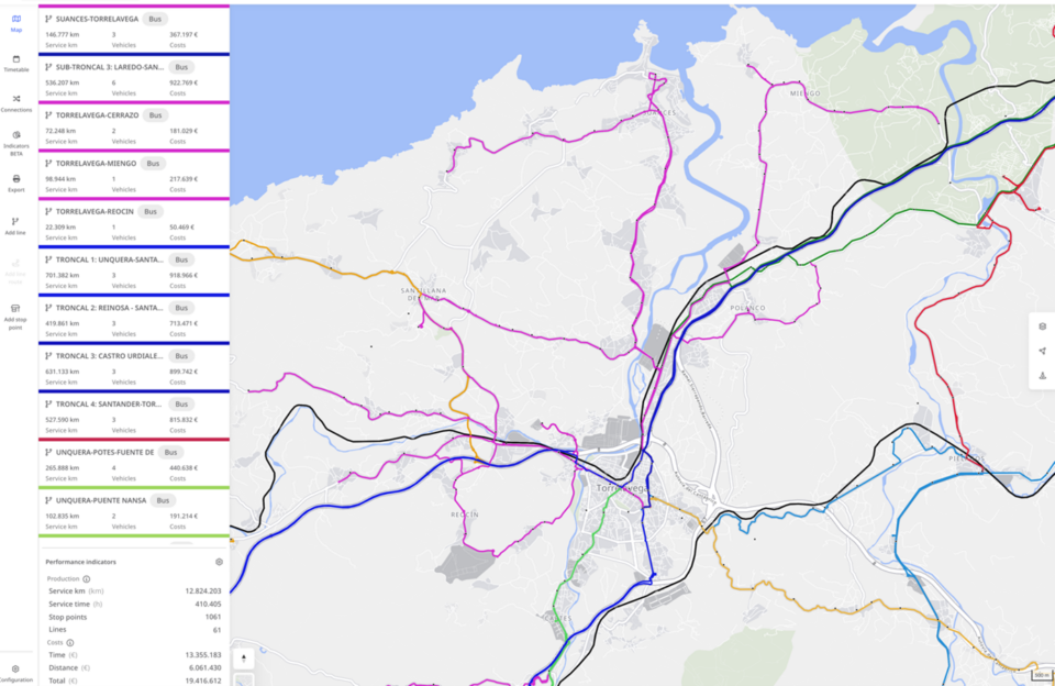
The project’s key outcome was the development of a comprehensive bus network design for Cantabria. The solution consists of:
- 4 high-frequency trunk bus lines connecting major activity centers.
- 48 regional bus lines serving local areas and linking them to the trunk network.
- 4 responsive service areas providing flexible transportation solutions in rural high mountain areas.
- Integration with 3 regional rail lines to enhance intermodal connectivity.
A critical aspect of the new design was the consideration of regional activity hubs such as healthcare, education, and sports facilities, ensuring optimal service coordination.
Key Performance Indicators (KPIs)
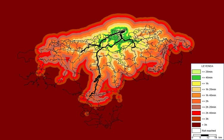
- Service Level: Improvements to travel times, available services, and accessibility improvements.
- Travel times: The use of isochrone maps and their comparison between the current and future situation makes it possible to evaluate travel times between certain time slots for each zone. A first general approximation of the system reports a 7.8% improvement in travel times. If this is analyzed for certain points or areas of interest (health facilities, educational facilities, county seats) and in certain time slots (8:00 10:00) this increases to 20% in travel time improvement and more services offered (an average of double the current ones).
- Operational Costs: Bus fleet requirements and cost per kilometer:
- The new system consists of 92 buses in circulation
- With an approximate cost of 12.8 million Euro.
- 233.397 annual service hours.
- 7.022.237,3 km of annual services.
- Average cost per kilometer of 1.82€/km.
Preliminary results indicate that the new system improves accessibility without compromising service levels, while achieving cost reductions compared to the existing network.
Conclusions and outlook
The use of PTV Lines has been instrumental in finalizing the design of the system, particularly in the fields of timetable synchronization and cost estimation. These features make it an invaluable tool for transportation planning and decision making. Its intuitive and visual system interface makes it a great tool for communication and collaboration between all project stakeholders.
Looking ahead, the insights gained from this project will serve as a foundation for further enhancements in public transport planning, ensuring sustainable and efficient mobility solutions for Cantabria.
Now, the Cantabrian government must publish public tenders to award lines to operators. These tender documents will include the basic characteristics of the new system: lines, sub-lines (routes), stops and timetables, as well as a series of other public service conditions.
The redesigned lines must be converted into concessions (contracts) that are economically balanced and comply with the minimum level of service defined in this project.

Step up your Public Transport Planning Game
Discover our Ultimate Guide to The Best Public Transport Service
Optimize public transport now
Use PTV Lines to plan the best routes and network improvements – without extensive resources


