

Table of contents
A mobility digital twin – what is it and how can it improve transportation?
Many cities continue to approach transportation planning by addressing issues as they arise. Naepo’s approach differs from the conventional model, offering a unique perspective that may serve as a valuable reference point for others.
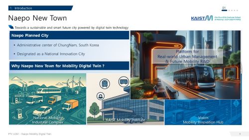
Naepo, located in South Korea’s Chungnam Province, is designed as a National Innovation City and administrative center. From the outset, digital transformation informed its strategic planning. Simulation was not merely an additional component; rather, it was a foundational element of the system.
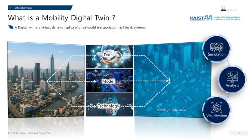
Naepo built a mobility digital twin: a virtual model that mirrors real-world transport using live data and simulation tools. This twin assists planners in evaluating concepts prior to construction. It facilitates data-driven decision-making, enhances teamwork, and ensures designs are future-proof.
This article will demonstrate how Naepo used PTV Visum and PTV Vissim to create its digital twin. You will also learn why this is important to projects worldwide: The insights from Naepo are applicable to any city seeking to implement data-driven mobility strategies.
Why a Mobility Digital Twin for Naepo?
The Naepo planning team needed a way to model and evaluate transport systems before physical infrastructure was built, ensuring data-informed decisions from the start.
To meet this goal, the KAIST Mobility Institute deployed PTV Visum and PTV Vissim. Together, these tools provide a multi-scale environment for analyzing demand, simulating multimodal interactions, and testing policy interventions.
The digital twin enables:
- Simulation of daily traffic and multimodal operations.
- Policy and infrastructure scenario evaluation.
- Testing of emerging technologies like autonomous driving and connected ITS (C-ITS).
- Immersive visualization and VR engagement for planners and citizens.
By combining strategic planning and operational modeling, Naepo has moved from reactive management to predictive, data-driven decision-making.
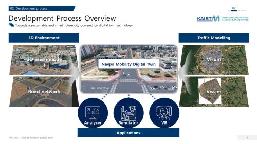
Building the Model: From Data to Deployment
The project’s development followed a structured approach:
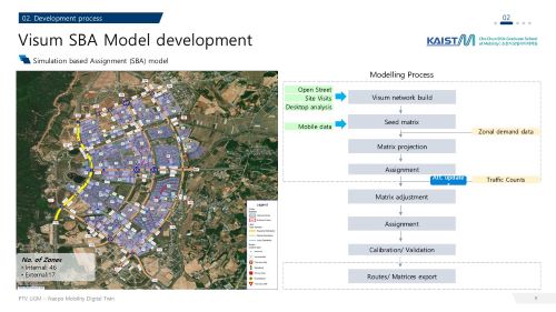
Simulation based Assignment Model (PTV Visum)
- Defined 63 zones (46 internal, 17 external).
- Built seed matrices using mobile data and traffic counts.
- Applied matrix adjustment, calibration, and validation to match observed flows.
- Combined OpenStreetMap (OSM) data, desktop analysis, and site surveys for a consistent road network.
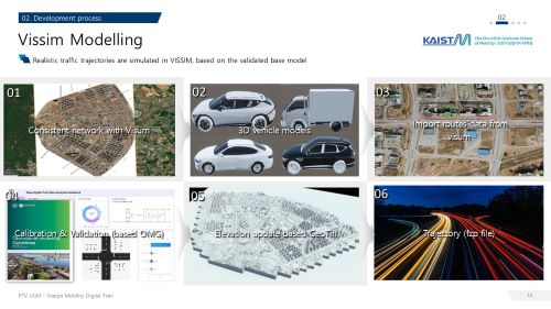
Operational Model (PTV Vissim)
- Imported demand and route data from Visum
- Integrated 3D vehicle models, elevation data (GeoTiff)
- Conducted calibration and validation following Operational Modelling Guidelines (OMG)
- Produced realistic 3D micro-simulations to support detailed operational analysis.
The result is a multi-scale digital twin of Naepo that links long-term planning with day-to-day operational insights.
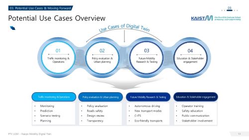
Practical Applications of Naepo’s Digital Twin
Traffic Monitoring and Operations: Integration with Intelligent Transport Systems (ITS) enables real-time traffic monitoring, congestion prediction, and optimization of management schemes.
Policy Evaluation and Urban Planning: Scenario testing supports decisions on road design, pedestrian safety, accident analysis, and policy review – improving transparency and collaboration among stakeholders.
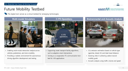
Future Mobility Research and Testing: Naepo serves as a testbed for autonomous driving, C-ITS, and green mobility strategies, including CO₂ estimation and acoustic analysis. The platform supports adaptive smart intersections and multimodal simulations involving vehicles, pedestrians, and micro-mobility.
Education and Stakeholder Engagement: Through 3D visualization and VR environments, the digital twin facilitates training, public communication, and collaborative design review – helping residents and policymakers understand mobility solutions in an accessible way.
Towards Data-Driven Mobility
The Naepo Mobility Digital Twin represents a step forward in how cities plan, operate, and communicate complex transport systems.
By integrating PTV Visum for real-time traffic operation and dynamic route choice, and PTV Vissim for high-resolution micro-simulation, KAIST and Naepo’s planners have built a foundation for:
- Smarter traffic management
- Sustainable urban design
- Evidence-based policy evaluation
- Safe and transparent testing of future mobility technologies
As Naepo evolves, its digital twin will continue to grow – integrating environmental and acoustic data with AI-powered analytics to guide the city toward smarter, carbon-neutral mobility.
Lessons for Global Mobility Planners
Naepo’s success wasn’t just about deploying advanced simulation software – it was about embedding simulation into the culture of planning from day one. For cities elsewhere, the key takeaway isn’t “use Visum and Vissim” – it’s how and when to use them.
So here are my tips for other mobility planners:
- Start Early, Simulate Often: Naepo didn’t wait for problems to arise. Simulation was used before infrastructure was built. Most cities still use modeling reactively – after congestion or safety issues emerge. That’s too late.
- Break Silos Between Strategy and Operations: Naepo’s planners didn’t treat strategic planning and operational modeling as separate domains. They built a feedback loop between Visum and Vissim. Many cities still isolate these functions, missing out on system-wide insights.
- Invest in Calibration, Not Just Visualization: The project emphasized rigorous calibration and validation. Too often, cities prioritize flashy visuals over data fidelity. A digital twin is only as good as its assumptions.
- Use Simulation to Democratize Planning: Naepo used VR and 3D visualization to engage citizens and policymakers. This isn’t a gimmick – it’s a way to build trust and transparency. Simulation should be a public tool, not just a technical one.
- Think Beyond Traffic: Naepo’s model includes CO₂ estimation, acoustic analysis, and multimodal interactions. If your city’s simulation only models cars, it’s not modeling mobility – it’s modeling yesterday.

Ready to Transform Urban Mobility?
The PTV solutions helping cities plan smarter, safer,
and sustainable transport
Ready to Transform Urban Mobility?
Discover how PTV solutions help cities plan smarter, safer, and sustainable transport networks


