
Table of contents
Urban mobility systems must adapt to extreme weather events that disrupt travel and strain infrastructure. Flooding is among the most critical challenges, reducing road capacity and forcing commuters to change modes. Therefore, flooding simulation techniques are vital for understanding how such events impact travel and infrastructure.
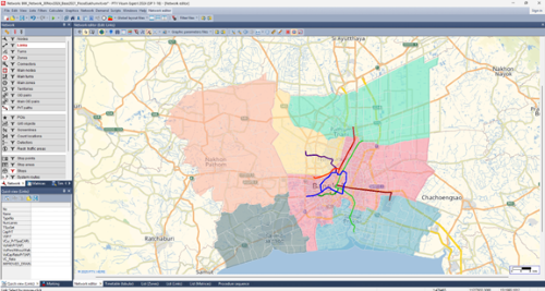
Our study, at Bangkok’s Kasetsart University, highlights how these disruptions affect travel behavior – and how cities can plan for resilience. Using PTV Visum, we integrated flood simulation with travel demand modeling to evaluate impacts and design strategies that keep people moving, even under severe conditions. While our case study focuses on Bangkok, the insights apply to any flood-prone city.
How we modeled flood resilience
We combined two tools:
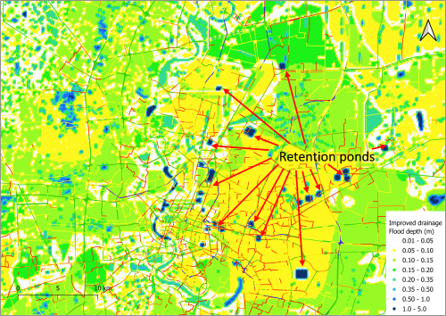
- Flood simulation (iRIC): Using terrain elevation, rainfall data, and drainage characteristics, we simulated inundation depths across the metropolitan area. Calibration relied on observed flood depths from past events.
- Transport model (PTV Visum): A conventional four-step model – trip generation, distribution, mode choice, and traffic assignment – calibrated with household travel survey data. The multimodal network included car, bus, and rail. We used this model extensively in our flooding simulation efforts.
We overlaid flood depths on the road network, reducing capacity and free-flow speed. We then fed these changes into Visum’s assignment and mode choice models, revealing how floods slow road traffic and push commuters toward elevated rail lines.
The scenarios we tested
We tested five scenarios:
- DRY: No flooding.
- F-EXD: Flooding with existing drainage system.
- F-IMD: Flooding with improved drainage (additional pumps, retention ponds, tunnels).
- F-IMD-TOLL50%: Scenario 3 plus 50% expressway toll reduction.
- F-IMD-RAIL50%: Scenario 3 plus 50% urban rail fare discount.
These flooding simulation scenarios allowed us to evaluate not just physical infrastructure improvements but also behavioral and policy interventions.
Results
Road traffic impact
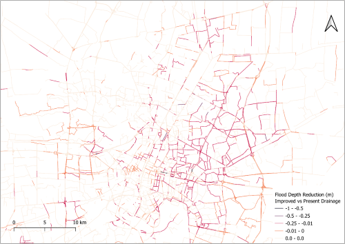
Flooding consistently reduced mobility. Under the F-EXD scenario, Vehicle Kilometers Traveled (VKT) decreased while Vehicle Hours Traveled (VHT) rose sharply, reflecting longer travel times. Even with improved drainage (F-IMD), congestion persisted, though conditions were moderately better.
- Expressway toll reductions (F-IMD-TOLL50%): Encouraged use of elevated highways but backfired by attracting more cars, worsening congestion in central areas.
- Rail fare discounts (F-IMD-RAIL50%): Increased ridership, particularly along corridors like Sukhumvit and Phaholyothin Roads, relieving pressure on flood-prone roads without worsening road congestion.
Mode shifts
Rail emerged as the backbone of flood resilience.
- In dry conditions (without rain), rail carried only about 4–5% of trips.
- During floods due to heavy rain, the share of rail mode increased along major corridors, particularly where elevated or underground lines provided uninterrupted service.
- With fare discounts, system-wide rail share increased significantly, confirming its role as a reliable alternative when roads are inundated.
Policy lessons for cities
Infrastructure enhancements alone are insufficient to ensure transport resilience. While improved drainage systems can reduce the duration of flooding, severe congestion persists in the absence of complementary transport measures. In contrast, rail systems function as a resilience anchor, as elevated and underground lines remain operational during flood events.
Policies that promote greater reliance on rail – through fare subsidies or measures to enhance service reliability – can play a pivotal role in sustaining mobility and mitigating vulnerability. This underscores the urgency of expanding rail capacity as part of a long-term resilience strategy.
Equally important is the design of policy interventions. Broad toll reductions, although politically appealing, risk intensifying congestion, whereas targeted approaches are more effective in managing demand. Instruments such as temporary rail incentives during flood alerts, dynamic road pricing, and selective toll discounts can encourage shifts toward more resilient modes, thereby enhancing the overall adaptability of the transport system by employing effective flooding simulation strategies.
Key takeaway
Flood resilience in transport is not just about better drainage – it is about keeping people moving. Using PTV Visum to link flood simulations with transport modeling shows that rail remains the backbone of mobility, and smart, adaptive policies can make all the difference for cities facing climate risks.

Model Resilient Mobility
See how PTV Visum helps cities plan for climate risks
Model Resilient Mobility
See how PTV Visum helps cities plan for climate risks


