Traffic calming measures – how can cities do them correctly? Here’s one example.
Nakło nad Notecią, a picturesque town in northern Poland, faces the challenge of managing high traffic flows, particularly through its historic city center. Despite the introduction of a bypass, congestion persists, negatively impacting the lives of residents and the town’s appeal to visitors. To address this problem, Nakło turned to the advanced simulation capabilities of PTV Vissim software.
This article examines the comprehensive project undertaken by Nakło, highlighting the challenges faced, the methodology used, and the impressive results achieved through the implementation of traffic calming measures.
Background about Nakło

Nakło, a small town on the banks of the Noteć River, has about 20,000 inhabitants. It is located within the larger urban area of the regional capital, Bydgoszcz.
Despite its modest size, Nakło has for years faced significant traffic challenges due to the lack of a proper road bypass. Transit trips, especially through the historic city center, contribute to congestion and inconvenience for both residents and commuters.
As a countermeasure, a road bypass was introduced in 2015. Despite this investment, the high volume of traffic through Nakło’s historic center still posed a challenge to urban mobility and the preservation of the city’s heritage.
Project Overview and Stakeholders
In response to these challenges, Nakło embarked on a project to analyze and implement traffic calming measures. The project was initiated as part of the 2021 Sustainability Urban Mobility Plan (SUMP), which aims to improve traffic management and the quality of life for residents.
The project involved collaboration between the municipality, consultants TOR and Modelab, and PTV Group. Consultancy firms TOR and Modelab played a crucial role in the development of the SUMP, which laid the groundwork for traffic management initiatives. PTV Group, as developer of the PTV Vissim software, provided technical expertise and support for the microsimulation analysis.
")
How PTV Vissim was used

PTV Vissim is an essential part of the project, offering advanced simulation capabilities to evaluate different scenarios.
The project team used PTV Vissim to test two future scenarios: maintaining the status quo (Do-Nothing) and implementing changes in the historic city center (Do-Something), both for the year 2035.
The Do-Something scenario included changes such as the introduction of one-way streets, speed limits, woonerf area, reduction of parking spaces and the introduction of a new parking area within walking distance (less than 200m) outside the historic center.
Project planners facilitated vehicle simulations using PTV Vissim’s Dynamic Assignment. They used matrices extracted from PTV Visum software to ensure accuracy and reliability. The Dynamic Assignment parameters, in particular the Kirchhoff exponent, were precisely calibrated to reflect the volumes from the strategic model.
A key aspect of the project was the innovative approach to pedestrian simulation using PTV Viswalk software’s Dynamic Potential method. This allowed for a comprehensive analysis of pedestrian behavior in dense urban environments, particularly within the proposed woonerf areas.
In addition, the integration of 3D visualization, combining data from the national database with Blender, provided a realistic representation of the cityscape within the simulation environment.
Results and Impacts
The results of the Do-Nothing scenario showed higher traffic volumes in the city center, causing significant delays and worsening current conditions.
However, the results of the Do-Something scenario were promising. They indicate a significant reduction in speeds within the city center and a corresponding reduction in average vehicle delay due to less variation in speeds.
According to the Do-Something scenario, the introduction of the woonerf area will lead to a significant reduction in car volumes. It will create a more pedestrian-friendly environment and revitalize local businesses.


Importantly, the simulations show that the nearby bypass will experience minimal changes, maintaining efficient traffic flow while alleviating congestion in the downtown area.
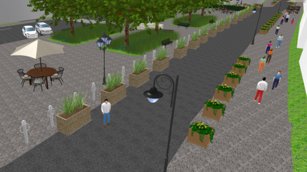
The images in this section are Vissim visualizations of the woonerf and historical square, in the Do-Something scenario of the project.
The next steps: Traffic calming measures

With the successful completion of the microsimulation analysis, Nakło is ready to move forward with the implementation of the traffic calming measures outlined in the project.
The town remains committed to improving urban mobility, preserving its historic heritage, and enhancing the quality of life for its residents.
Plans may include further refinement of traffic management strategies based on real-world data and stakeholder feedback.
Bartosz Chuderski, modeling expert and owner of Modelab, said: “Strategic planning is at the core of transportation studies. So it’s great to see how our study is being used for the next stage of analysis for Nakło. The first results have been important for the continuation and analysis with a detail-oriented approach in PTV Vissim. The combination of both strategic scale and micro scale adds value to the whole process. “
Maciej Mysona, project manager at TOR, added that he was excited to use micro-simulations in the Nakło project: “It’s important for the public to understand how these simulations help make informed decisions about traffic flow in the area. The combination of strategic planning and microsimulation in this project is truly commendable. It gives us a deeper understanding of how proposed changes can affect the daily lives of the people of Nakło.”
Conclusion
The case of Nakło serves as a fascinating example of the use of simulation technology to address congestion in historic city centers, and to better plan traffic calming measures
Through collaborative efforts of stakeholders and the innovative use of PTV Vissim simulations, Nakło is on its way to successfully optimizing traffic flow, improving pedestrian safety, and revitalizing its city center.
As cities around the world grapple with similar challenges, Nakło’s experience offers valuable insights and inspiration for sustainable urban planning and mobility solutions.

Related Products
Related Posts


