The recently approved metro project for the Tel Aviv Metropolitan Area is among the largest infrastructure undertakings in the world today. It will feature three lines, 109 stations – seven of which will serve as transportation hubs – and span 150 kilometers, all constructed from the ground up. This extensive network will cover a total of 19 municipalities within the metropolitan region.
The M3 line, designed as an arc to connect the other two lines, intersects with the M1 line at its southern end at the Yoseftal Holon hub station. During peak morning hours, trains are projected to arrive every three minutes at each of its four platforms, with an estimated 15,600 passengers boarding and alighting from all directions.
The company Mahod Engineering Ltd. is responsible for the planning of the M3 line of the Tel Aviv Metro – together with InProject, MLead and Artelia; and this simulation was made for the tender submitted by Mahod Engineering Ltd. for this project.
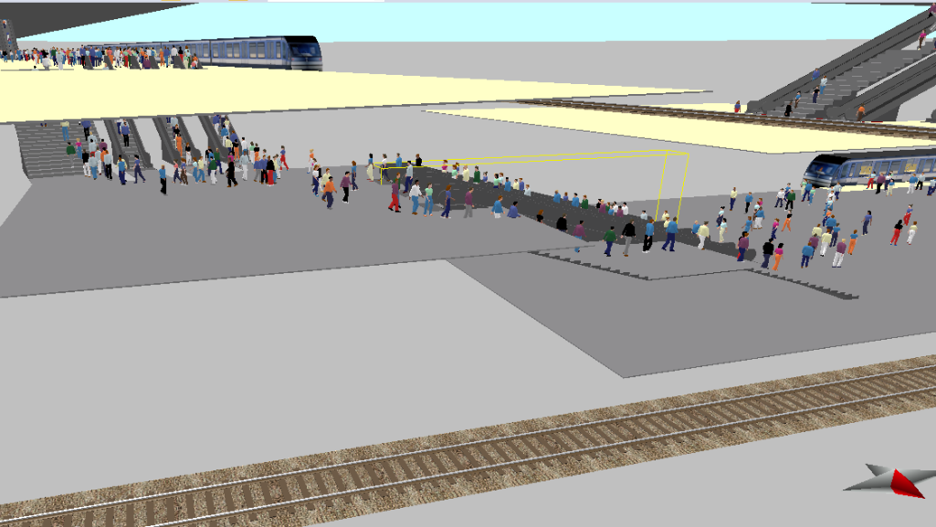
In a modeling project, we analyzed pedestrian flows throughout the Yoseftal Holon hub station to improve overall usability and safety.
Building the model

In order to build the multi-stories model with PTV Vissim/Viswalk, it was helpful to visualize the project in its BIM 3D version, to then create each level according to its elevation, and only then adding the elements overlaid on the DWG files (loaded as background images). The volume of passengers traveling at the model was calculated in order to distribute the 15,600 passengers according to the following formula:
Passenger Distribution
Street-level Entrances:
- 5,400 passengers enter the station from street level through four entry points. They proceed downstairs to the platforms to board one of the four trains arriving every three minutes.
Train Arrivals:
- An additional 10,200 passengers arrive at the station via trains. These passengers alight from the trains, which make 20 trips per hour each.
- The alighting passengers are divided into two groups:
- Those leaving the station to street level.
- Those walking to another platform to transfer to a train on the second metro line.
Goals and Objectives
A microsimulation of peak-hour passenger and train traffic helps identify potential bottlenecks and optimize routes within a complex and crowded transit hub. Developing this model early in the project allows engineers and architects to detect gaps and make necessary improvements to the plans before moving on to later stages.
Analyzing the simulation results offers another advantage: it enables the determination of the optimal placement for wayfinding signals and allows for the programming of the most efficient direction for each escalator within a set of three parallel escalators.
Steps for solving technical challenges (Obstacles)
Designing and improving pedestrian routes in Viswalk necessitates innovative solutions to accurately simulate natural pedestrian behavior. The aim is to prevent pedestrians from taking undesirable shortcuts or overly straight paths, which would render their movement unrealistic in complex scenarios with large crowds.
The solutions for managing pedestrian path behavior involve creating additional invisible areas to better shape each pedestrian route and adding surface-level obstacles to redirect flows away from undesired paths, such as between or under escalators. In real life, these obstacles can be represented by small commercial areas like kiosks, bollards, handrails, stanchions, and plant vases. These physical elements are strategically placed to influence pedestrian flow and guide them away from unwanted paths.

Key Findings
")
A model as expansive as this, featuring two interconnected five-story complexes with multiple entrances and exits, requires meticulous examination of every detail. In this project, visual-based analysis was the primary method used to assess traffic flow quality. This approach aids in identifying and resolving bottlenecks or inefficiencies effectively.
Simulations were conducted 140 times, focusing on specific elements such as escalators, staircases, elevators, and gates. This process led to the optimal configuration for staircase direction and the placement of obstacles and path markers. For example, groups of three parallel staircases generally perform best when two staircases ascend and one descends simultaneously. The decision on which staircases ascend or descend is based on optimizing pedestrian movement across multiple floors.
In scenarios where staircases are positioned at corners connecting different floors at angles, passengers typically transition to the nearest staircase upon exiting the previous one. However, conflicts and bottlenecks can occur when groups of passengers move in opposite directions. These issues are mitigated through traffic calming measures and redirection strategies.
This comprehensive approach ensures efficient pedestrian flow throughout the complex, improving overall usability and safety.
Results and conclusions
In a large and complex hub station like Yoseftal Holon, even minor improvements to passenger flow are crucial and should be implemented. Modeling the movement of people within such a densely populated environment presents significant challenges during peak hours, where efficiency, smoothness, and, above all, safety are paramount. Small adjustments, such as optimizing wayfinding through the strategic placement of staircases and elevators, can complement other information-based measures. For instance, passengers disembarking from a train who need to transfer to another platform can benefit from boarding specific cars that align more closely with staircases linking both platforms.
Digital signals can play a pivotal role here by dynamically guiding and instructing passengers on station floors and walls, as well as inside train cars. By integrating these adaptive directional cues, Yoseftal Holon can improve passenger navigation and ensure a safer, more efficient travel experience during peak periods.


